Search This Blog

Sunday, July 11, 2021

The Freedom Rock and Hoskins Wildlife Area


Ray 'Bubba' Sorensen II repaints The Freedom Rock every year in time for Memorial Day. 

We hadn't been to see it yet this year, so after leaving Mormon Trail Park we drove up to look at it. (About 12 miles North of Greenfield on Hwy 25. A mile or so South of I-80.)

This is the side facing the highway.

The remembrances left on and near the light pole on the other side of the barrier always intrigue me.


South side, remembering Pat Tillman.


East side.


Close up of young boy on the corner of the East side.


North side.


There were once working rock quarries on both sides of the gravel road east of the Freedom Rock. (Which is where the massive stone came from.) These two quarry lakes are now so lovely and peaceful. 


Chicory and wild oats near a chunk of limestone.


Chicory, wild oats, wild grapevine and limestone.


Chicory, wild oats, Queen Anne's Lace and limestone.

I probably made more studies of the wildflowers and limestone than I did of the Freedom Rock.

My heart resides in Nature.


On the way to the other area of wildflowers the Mormon Trail park ranger had told us about, driving down a gravel road when we saw four, what I thought at first were dogs, running down the road toward us. They turned out to be two does and their fawns.
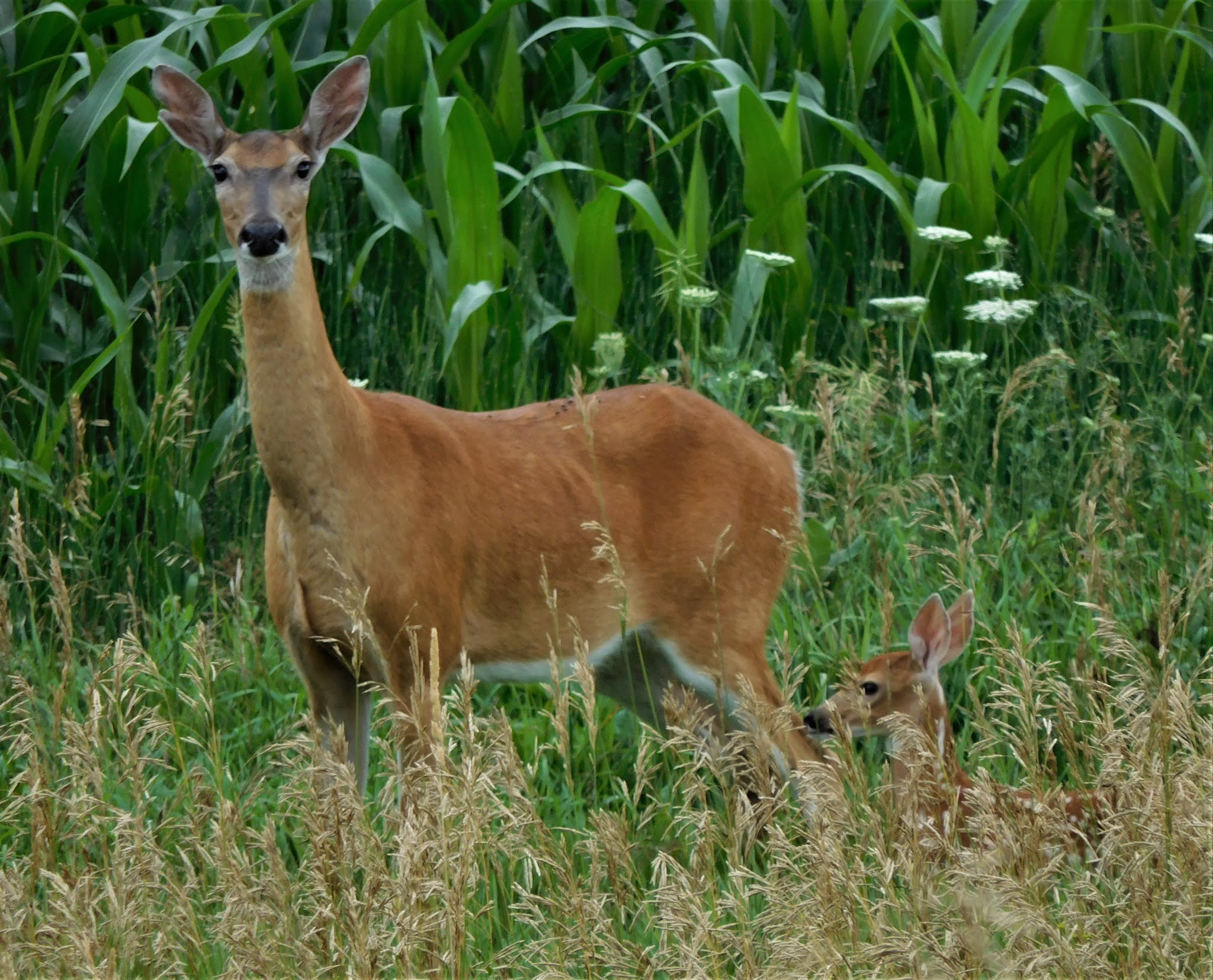


I was able to get pics of all four, though the fawn in this one is almost hidden by the grasses.


Hoskins Wildlife and Prairie Restoration is one mile North of Nevinville. It was the 120 acre farm of Pete Hoskins which he donated to the Adair County Conservation board in 2010.


The Southeast section of the area seems to have most of the wildflowers.

And lots of birds and birdsong. That little black speck is a Red-winged Blackbird.
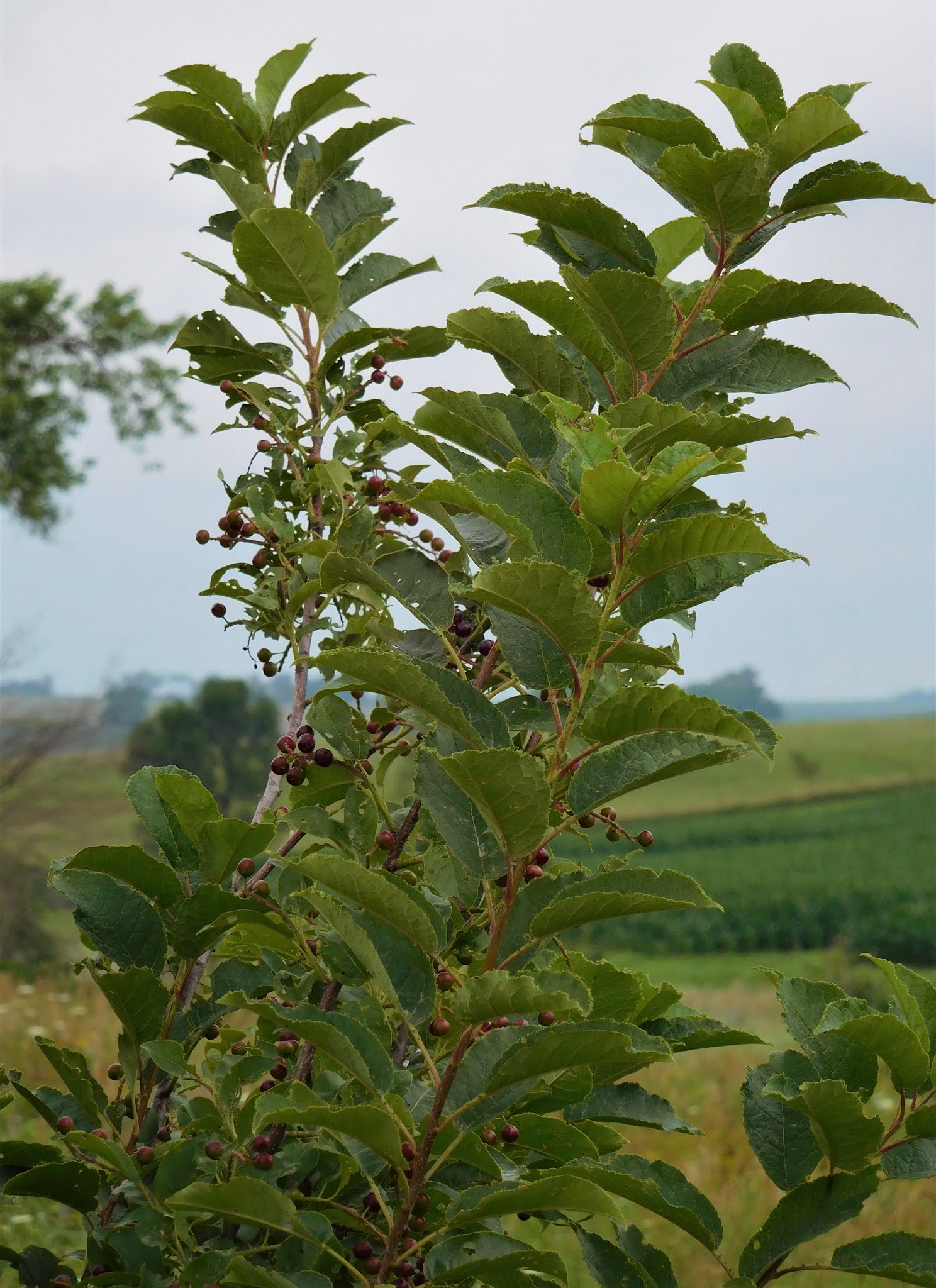


I'm not having any luck identifying this bush? tree? The berries are ripening, so hopefully the birds will enjoy eating them.


A farmstead in the background, wildflowers and another view of those berries.


I think the lavender flowers in the middle of the photo are Monarda, aka Bee Balm. Other names are Bergamot and Horse Mint.


It would be interesting to come back here during other seasons of the year to see what is blooming.


As well as on a sunny day when the colors might appear more vibrant. And we could walk through the prairie without getting wet. 
Maybe find the 2-acre pond and see what else we might have missed.


Last photo of the trip, taken looking uphill.
There had been a small bird perched on one of the plants but it flew before I got a photo.

I think the tall grass might be Big Bluestem. 


It was such a delightful morning. We were gone four hours - not many miles away, but in another realm altogether.


Later in the day I asked Bud what his favorite part of our excursion had been. He said: "Seeing all the changes at Mormon Trail Park."

"Really? That was my favorite part too."


Saturday, July 10, 2021

Mormon Trail Park & Lake - Part II


There is no road around Mormon Trail Lake so to reach the beach area and the remainder of the park you have to go out the entrance, go north on the road to the first corner, turn right (east) and go about a half mile to the other park entrance.

This area of the park was different from my memories, too. Different entrance fewer trees, etc.

The park ranger had just finished harrowing the sand so we were the first to walk on it Wednesday morning.

The last time I camped at Mormon Trail was with my granddaughter Deise, probably about 20 years ago. We swam at this beach. The water was the clearest, cleanest, I had ever seen at a lake. It is still almost as clean 20 years later even though the park sees many more visitors now.


I really enjoyed this side of the lake because of all the flora.

I had some Swamp Milkweed when we lived on the farm. It was almost as beautiful as these.


Another view of the Swamp Milkweed with cattails.


For comparison, this is Common Milkweed with some Queen Anne's Lace.


A view of the roped off swimming area and the less developed east side of the lake - taken from the tip of a small peninsula extending into the water.

There is still plenty of room for expansion if funds allow for further development. 


We drove past this small pond on the way toward the beach area. I noted the waterlilies and planned to stop on the way back out.

But I forgot and almost drove past when HD asked: "Didn't you want to stop here?"


My eyes were first drawn to the vivid purple behind some white waterlilies.

This is a new plant for me - Pickerelweed. Perhaps I've seen it before and just thought it was Purple Loosestrife?


Eventually I actually listened to what Bud was saying: "Did you see the pink ones?"

Oh, my goodness! I hadn't really even looked at the waterlilies in my haste to photograph the Pickerelweed.


I have never seen pink waterlilies before.

I am totally in love. They are just so gorgeous.


Of course the white ones are still beautiful, too.

But there is, for me, just something about blush pink.


This was about the time the park ranger stopped to visit with us.

He asked if we were having a good time photographing all the wildflowers and then pointed to an area that was out of our sightline.

If he hadn't, we would have missed the Butterfly Weed and Rattlesnake Master.

He also told us about another area of prairie wildflowers we might want to see. More about that tomorrow.

This was the last flora photo I took before leaving Mormon Trail Park.

It is a reminder of my childhood because there was such a large patch of it near our one-room country school.

I liked to pick it and pull it apart at the joints because it made a popping sound. I think I even called it pop grass or snap grass, maybe even snake grass.

Its common name is rough horsetail, scouring rush or scouringrush horsetail. I should be able to remember horsetail, but I never do. I always have to look it up.

According to Wiki, in South Africa it is known as snake grass so maybe I wasn't so far off after all.


Friday, July 9, 2021

Mormon Trail Park & Lake - Part I


We've had a trip back to Mormon Trail Park in Adair County on our list of adventures to do for quite awhile. Wednesday morning was 'the day'. It had been raining, but was supposed to clear, so off we went.

First stop, the old bridge across the West Fork of the Nodaway River southeast of Bridgewater. I really like the old steel bridges and taking photos from them. Crossing long bridges over a big river has scared me all my life, but this size, not at all. Though when I walked across it -- talk about the need for infrastructure funding!


Upriver view. 


There's a wild morning glory growing on that wee island.


"Bloom where you're planted."   


As we drove into the park I pointed up to the right and said: "There's the big tree we were camped under the night the Bridgewater volunteers drove through the campgrounds warning of a tornado and telling us to go to the fire station to shelter." (We stayed in our tent.) 

We asked ourselves: "How long ago was that? Twenty? Twenty-five years?" It doesn't seem possible.


HD referred to these grass carp feeding as "Iowa's version of Shark Week. 😄


The water is just as clear as I remembered it.


Raindrops on a spider's web between the boards of a boat dock.

(An artistic attempt.)


"There's that little bridge to the campground that I remember - but it is in a different location and a whole new campground area."

There was only one camper, a bicyclist, and he was preparing to leave. We learned he was following the historic Mormon Trail across the country.


Old stone retaining wall at one of the new camping spots....

....with sedum just like what I kept a start of from Mom's sedum at the farm.

Around the corner and up the hill, we veered to the right and stopped at the historical marker. While Bud read that, I took umpteen photos of the native prairie and wildflowers.


This area is extensive, and beautiful.

According to the signage, the Mormon Trail followed along that ridgeline where the trees are.


Walking trails are another new (to us) feature.

We had planned to walk some of these, but they were still wet.

Plus, we still had much more to see.


Purple Coneflowers were abundant. Pictured here with some Rattlesnake Master and an attractive, slivery leafed plant I haven't been able to identify.


Abundant and gorgeous!


Lovely white Queen Anne's Lace.

I think the yellow may be Wild Parsnip.


Looking north across the lake from a hilltop on the south side. The lake isn't huge, only 35 acres, but it is perfect for fishing (electric motors only) and kayaking.


We were being sung to the whole time we were on the hill. I finally got a photo clear enough that I could identify this Orchard Oriole.


Oh, also in this area is a shooting range. I was going to post this picture (The Well Armed Woman) on FB and say: "I've found my tribe", but I figured someone would take me seriously and I would start getting invitations to join the NRA. 

Tomorrow - The other side of the lake. 

We would leave the park in another direction - so one last photo from the bridge area of the first pictures.

Wild white morning glories, funji and wild grape vines. 


Thursday, July 1, 2021

Locating 'The' Bridge


We visited a number of historic bridges on our trip to Linn County last week, walked across them, took a bunch of photos of them and from them.


And posed on bridges in a couple state parks.


But since learning about a bridge on one of the grass trails on the west side of the lake at Green Valley State Park, I've wanted to find it. We had been on the trail from the north end. Yesterday was the day to explore from the south end.


Beginning at the farthest west parking lot near the spillway didn't appear very promising.

All we got was wet feet from walking down closer to the lake shore.

No path there that we could find.


So we drove west to the highway, north to a dead-end gravel road, east on that road, past some turkeys in a soybean field and back into the park where there were choices about which way to go.


The left path lead to the causeway and we'd already been that far from the north, but at least we knew where we were.

The middle path only went down to the edge of the lake and back.


The path to the right, south, past the meadow daisies remained, so we went that way.


Past a pretty little, dainty, blue damselfly.


Past a huge brown, scary spider hiding somewhere there under the clover and weeds, near its web.


Until there it was, finally, about a half-mile from where we started in the parking area at the dead-end gravel road.


We were surprised to find that the bridge railings, that looked so much like wood in the picture we had seen, are actually iron.


We decided not to go any further on the trail, choosing instead to wait until another day to find the start of it from the south.

Heading back across the bridge, I noticed these two Fritillary Butterflies both fluttering arduously as though they were caught.


HD valiantly waded through the tall, dense weeds until he could get close enough to reach them with his walking poles.

They were caught in a spider web. He freed them, placing them away from the web.

Hopefully, they survived and after resting flew away.

I took a couple more pictures from the bridge - this one looking through the railings, showing all the lichen on them, down to the little creek.


And this one from the other side where the creek meanders on - adding its flow to the waters of Green Valley Lake.


It was a very successful trek, but the day was aready warming up and it wasn't even 10:00 a.m.


Next time, we'll walk the remaining sector of this grass trail, which will leave only one small section of Green Valley trails untrod.